Two is almost always better than one — save for mingling, binary hurricane swells (creating what’s known as the Fujiwhara Effect), where one subsumes the other and typically cancels out the potential for either to kick up quality surf. But Tropical Storms Hilary and Irwin, a pair of eastern Pacific storms spinning westward between Southern Mexico and Hawaii, could be an exception to the rule for Southern California this weekend and through Monday. Generous forecasts early this week reported estimates of wave heights not seen since Hurricane Marie in 2014. Hilary has since been downgraded as it travels away from the west coast of Mexico, but questions remain over the next 24 hours thanks to the uncertainty of the Fujiwhara interaction. Should you be waxing your step-up board this weekend in SoCal?

SwellWatch forecaster Nathan Cool answers some questions:
First, let’s talk hype factor. Should we be pulling out the 6’6″s this weekend?
I wouldn’t say so. For a hurricane swell for Southern California, it’s going to be significant. But that’s for a hurricane swell. We get much bigger swells in the wintertime coming off the North Pacific. South-facing breaks sometimes see bigger surf even from large storms that we get from the southern hemisphere. But this is unique for hurricane swells in that, a lot of times, hurricanes go directly west. They stay in colder water. This time around, this hurricane would have done that same thing. It would have been similar to, say, the swell that we got from Hurricane Eugene: it was fun, but there weren’t epic conditions.
When you put in the Fujiwhara effect — that is, Irwin’s binary interaction with Hillary, and potentially with some interaction from Greg, making it somewhat of a triple Fujiwhara — that’s a unique story. We could possibly get a better trajectory out of Hillary. It could possibly strengthen Hillary a little, too. Most of the time, with these storms, one will completely absorb the other. It’s almost like two binary stars in the cosmos, where they’re orbiting each other. If Hilary is swirling one way, it all of a sudden makes Irwin go back to the east, beneath Hillary. Them, if Irwin wants to go north, it pushes Hillary north. So they’re both influencing each other.
At one point, a few days ago on the models, it was coming with estimates with 15-foot wave heights in Southern California. But really, that was only for a short period of time. A lot of models have downgraded it since then. What seems to be confusing the models the most is the Fujiwhara. If not for that, the models would have a much easier time in predicting the conditions. But this is a new snag that are making things more difficult.
When surfers read the reports, what’s the most important variable to take note of?
The most important thing is to see where the swell will be coming from. That’s common with any storm, but especially so with this one. SoCal is unique – It’s hit from all kinds of different angles. We’ve got islands that block swell. Hillary has faded in strength right now, and that’s doing so before it crosses what I call our “surf-worthy rubicon,” which is around the longitude 110 W. When it crosses that, it still isn’t an ideal swell angle for Southern California — that’s when it’s about 160 degrees. That’s really tough. Most of the energy would get lost out to sea. Only some of it would brush Southern California.
Initially, some of the swell will be angled that way. As Hilary continues to travel, she will go further west, even if she goes further north. That’s where it improves the swell angle.
But you have to be careful about what breaks you select. During the peak of the swell, we’re looking at primary swell energy coming from 175- to 185-degrees, so Malibu will likely get blocked by Catalina. Orange County, especially Newport, tend to go off. Santa Barbara gets blocked by the Channel Islands at that point. San Diego surfers are going, Where’s the swell? because they’re facing the west.
So it’s a tricky angle for Southern California, but by around Monday, if things do hold true, the swell angle will widen a little more, for a southwest angle. We could be looking at 2-4-foot overhead at some points, and maybe some standout double-overhead sets as well [Ed. update, from Nathan Cool: new reports estimate more of a head-high + event for SoCal, because of the downgrading of Hilary and its weakened interaction with Irwin]. That’s if you can pick up that angle, and you don’t have anything blocking it.
Is there any preliminary reading with this swell that strikes a similar chord to Marie?
There’s not much relationship. Marie turned into a Category-5 storm. That was the big reason why we got such enormous surf from Marie. Also, speed was a rally important factor. Once we get to about 9 knots or slower, waves can pick up stronger and stronger fetch [Ed. Note: at the time of this story, Hilary was moving at around 11 knots]. Marie was a quick-moving storm. It was more of a slam-dunk type of forecast with Marie because there was no Fujiwhara. I’ve been forecasting for over 20 years, and this is the first time I’ve seen a Fujiwhara actually have a positive influence. Getting this binary dance between the two where one’s not consuming the other is sort of uncharted territory, and it’s why the models are having such a struggle.
Any other details worth noting in regard to tracking west coast hurricanes?
This thing falls within a 36- to 48-hour swell window, maximum. Most of the time, it’s a 24-hour swell window. Trying to forecast this far out, there’s still some uncertainty. We’re talking about 30-foot seas being only 700 nautical miles from Southern California, directing toward us. That’s very close. Instead of seeing 16- to 18-second periods arrive one day, and another day seeing 14- to 16-seconds, and seeing shorter and shorter periods, all kinds of swell will be thrown our way. Sets will probably be inconsistent, but but once again, it depends on how well you are exposed to that direction of swell.


 LOLA wave height chart in the EPAC. .


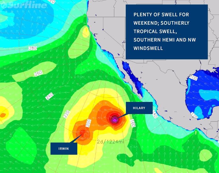 LOLA wave height chart showing possible Fukiwhara effect between Irwin and Hilary.


Social Buttons