Latest News

Some more fun waves for Sunday at the Venice Pier. These photos were shot by Six12 Media. If you were out there, you probably got some surfing shots in the photo gallery, check them out, the link is down below.


You can find these and over 150 more photos from this session, all full size and in high-resolution, in this photo gallery:

Venice Pier - Sunday 7-8-2018 Gallery


If you were out there, we probably got some cool surfing shots of you, go check them out!


Wanna see photos from previous days at this and otherlocal surf spots?
Click Surf Spot Galleries and look for the spot and then the date.


Some fun waves Saturday afternoon at the Venice Pier. These photos were shot by Six12 Media. If you were out there, you probably got some surfing shots in the photo gallery, check them out, the link is down below.


You can find these and over 300 more photos from this session, all full size and in high-resolution, in these 2 photo galleries:

Venice Pier - Saturday 7-7-2018 Gallery #1
Venice Pier - Saturday 7-7-2018 Gallery #2


If you were out there, we probably got some cool surfing shots of you, go check them out!


Wanna see photos from previous days at this and otherlocal surf spots?
Click Surf Spot Galleries and look for the spot and then the date.

Plenty of Swell Over Weekend, Next Week Too.
Surf heights for Southern and Northern/Central California on Friday morning.

Selective SSE Tropical swell from Fabio peaks Friday
Modest to solid size for SoCal, NorCal misses out
Tropical swell is fading through the weekend
S Hemi and NW windswell take over early next week


Perillo, Sarlo, Meador and the Brothers Marshall revive classic surfcraft at Malibu

“Malibu is one of the best waves on the California coast,” Bird says. The legendary cobblestone right-hander typically calls for flatter boards with straighter rails and Bird knows just what to curate from his shed of diverse surf craft for that. A couple of sub six-foot classics and two traditional single fin logs.

Malibu’s resident rippers Dillon Perillo and Colton Sarlo trade-off an early model 5’10” Mark Richards twin fin from Gordon & Smith, and a pink 5’10” Terry Fitzgerald shape with a unique fin setup, a board shaped for first ‘CT World Champion Pete Townend.

For the loggers, Bird pulls out a 9’6″ Gary Propper model from Hobie Surfboards. “This thing at Malibu should blow some peoples’ minds,” Bird says about the board. After scoring a few waves on it, Chad and Trace Marshall share the same sentiment. However, the regularfoot Brothers Marshall didn’t experience the same magic on the 8’6″ Hobie Corky Carroll model, but goofyfoot Kassia Meador scored a few noserides on it and summarized the board as “epic.”
Hurricane Fabio has intensified within the SoCal swell window today. We are seeing latest winds of 90kts with gusts up to 110kts. The track has been generally ben to the WNW, picking up see to around 13kts over the past 6 hours. We are starting to see swell fill in for Baja. Swell from this will start to impact SoCal over the back half of the week.


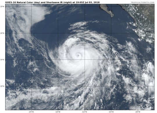
Visible satellite imagery is showing a better developed storm with the eye becoming more clear over the last couple of hours. This may allow Fabio to intensity just a little further, but the storm is nearing peak intensity. Fabio is just on the leading edge of cooler ocean waters and oceanic heat content. This is going to result in rapid weakening of the storm as it continues to track WNW/NW over these cooler waters and stable environment.


Storm force winds extend outwards 140NM from the center of the storm on the east side in the SoCal swell window. We have seen vigorous convection in this area which usually means we are seeing a good amount of winds mixing down to the ocean surface which is good for swell generation. To give that some perspective, the very large Hurricane Marie in 2014 had an estimated south to north fetch on its eastern flank of 500 miles. So while Fabio is smaller, it’s still a good size storm and the largest we have seen this season.

The final piece of the puzzle for tropical swell is shaped by the storm’s track. For Southern California and Baja we see the largest swell when storms take a northward track toward us at a slow pace (10 knots or less). Fabio is a bit mediocre in this department and has been on a WNW to NW track in the 9-13kt range over the past 24-36hrs. With the vast majority of models in strong agreement on Fabio’s track, we’re of high confidence on this aspect of Fabio.

One other factor that is somewhat related to track is Fabio’s location. The storm is a bit further south than the average swell producing tropical cyclone by perhaps 200 miles. This will lead to at least slightly greater swell decay and slightly smaller surf than a storm that is closer.

For Southern California surf we’ll look for a building/peaking trend for the second half of the upcoming week, with potential for solid surf at the breaks that can pick up the extreme angled SE to SSE swell (Orange County, parts of LA and Southern Ventura and a few select other breaks).
All Eyes on Fabio; NW Windswell, SPAC Swell .
Surf heights for regions along the California coast on Tuesday morning.

Modest/fun S swell blend through middle of the week
Healthy NW windswell for areas north of Pt. Conception
Larger pulse of tropical swell from Fabio later in week
S hemi swell lingers; NW windswell fades into weekend
ZJ Boarding House's 4th Of July Sale! Save 50% on ALL their 4th of July Gear now through the 4th!

ZJ Boarding House
2619 Main St. Santa Monica, CA
(310) • 392 • 5646
Store Hours:
Mon - Sat 10am - 7pm
Sun 10am - 6pm

The Ocean Park Association is once again hosting the 12th Annual Santa Monica 4th Of July Parade on Main Street, Santa Monica. The parade is scheduled for Wednesday, July 4th, at 9:30am. The parade theme will be a celebration of "Bringing Communities Together”.


More photos from the past parades here:
2016 Santa Monica 4th Of July Parade Photo Gallery

From: http://www.noaa.gov/

Beach Hazards Statement
Alert:
.A large southerly swell will move into the waters Wednesday evening, peaking in height Thursday afternoon through Friday morning, then slowly subsiding through Friday evening. Surf heights between 8 to 11 feet will be possible on exposed south facing beaches. Sneaker waves will be possible Wednesday evening through Thursday morning, with strong rip currents on many beaches throughout the event. Powerful breaking waves are expected in many areas.

...BEACH HAZARDS STATEMENT IN EFFECT FROM WEDNESDAY EVENING THROUGH FRIDAY EVENING... The National Weather Service in Los Angeles/Oxnard has issued a Beach Hazards Statement for Outlook For High Surf and Strong Rip Currents, which is in effect from Wednesday evening through Friday evening.

* HAZARDS...Surf building to 8 to 11 feet on south facing beaches, such as Port Hueneme, Zuma Beach, Cayucos, and areas near Long Beach. Strong rip currents are certain, and sneaker waves will be possible. The surf will begin to subside Friday afternoon and evening.

* IMPACTS...There is an increased risk for ocean drowning. Rip currents can pull swimmers and surfers out to sea. Large breaking waves can cause injury...wash people off beaches and rocks...and capsize small boats near shore.