Saturday, January 1st: Short-period NW swell drops, cleans up with offshore wind. 3-4′ surf early. NW swell mix eases through the day after a predawn peak. Surf is waist-stomach high at average exposures as decent winter spots pull in a few larger peaks to chest high. Surf is much cleaner with widespread offshore flow in the morning though many zones struggle with the morning high tide — let it drop some.
Sunday, January 2nd: Small and clean morning. 2-3′ surf for best winter breaks. Shorter period NW swell mix drops off through the day as some small new NW swell shows. Surf is below waist at average exposures as decent winter spots pull in a few rideable waves. Surf is clean most of the morning just keep in mind that many zones will struggle with the early high tide — let it drop some. Weaker offshore flow in the morning trends lightly onshore for the afternoon.

A fairly significant pattern shift is expected in the Gulf of Alaska this weekend. The persistent ridge of high pressure over the region will finally break down as models indicate strong low pressure developing in the region. That suggests potential for longer period NW swell mid to late next week. Most of the fetch is looking pretty steep (300+) for Southern California, which will limit size, but it should still offer a few fun waves for good winter breaks. Average breaks run waist-stomach high with lully sets to chest high for good spots later Tuesday into Wednesday the 5th. More mid-period, NW swell mix may follow for next weekend thanks to a storm expected to push across the northeast Pacific towards the West Coast. The direction is a touch more westerly than the midweek pulse and the period looks a bit shorter, so the nature of the swell could help spread a few more waves across the region.


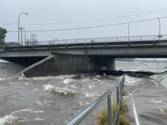


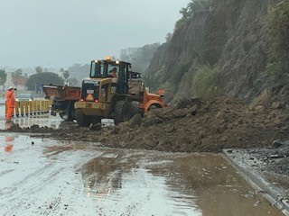

 At 4:22 a.m. L.A. County Fire Department responded to a water rescue call at Leo Carrillo State Park. Approximately 50 people assisted to safety, no injuries reported.


.png)


Social Buttons