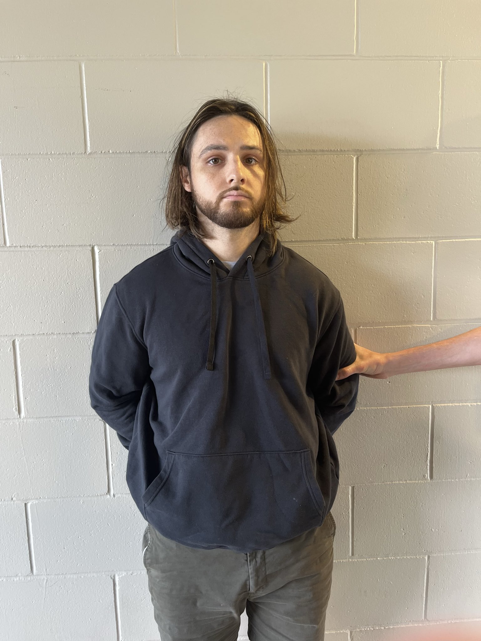
Latest News
Showing posts with label Topanga. Show all posts


Topanga Canyon Boulevard (SR-27) remains closed to the public for safety reasons between Pacific Coast Highway and Grand View as extensive cleanup and repairs continue. The closure is to protect the public from serious injuries and fatalities.

Caltrans is prepared to open the road as soon as it is safe to do so in coordination with the California Highway Patrol, utilities and local public agencies.

Caltrans expects to open one lane to school buses during designated times with an escort this week and is working on a plan with its partners to also allow essential business travel during this timeframe.


Progress has been made in cleanup efforts, with at least 8,600 cubic yards of mud and debris — equivalent to 860 truckloads — removed so far of the 33,000 cubic yards that came down on the highway after the February storm. All mud and debris are being pushed to the side of the road and tested. Clean dirt will be sent to Oxnard farms for reuse. To date, all dirt has tested clean.

Caltrans and its partners are working to restore Topanga Canyon Boulevard by building retaining walls in three locations and rebuilding the shoulder and lane where the road was washed away. Rebuilding the shoulder and lane will take at least a month, once a design is in place. Additionally, multiple locations throughout SR-27 will require the installation of debris flow barriers and installation of larger culverts. These improvements will help minimize the impacts of future debris/mudflows on SR-27 due to the extensive burn scars in the canyon..


For more news, updates and traffic conditions on PCH and other local beachside roads, Click Here.

For more news and updates on the Palisades Fire, Click Here.


As of Friday, March 14 at 4 PM, Pacific Coast Highway in the Palisades burn area is under a temporary FULL CLOSURE from Carbon Beach Terrace to Coastline Drive due to continuous rock/mud/debris flow onto PCH at Big Rock. Only emergency vehicles will be allowed through.


For more news, updates and traffic conditions on PCH and other local beachside roads, Click Here.

For more news and updates on the Palisades Fire, Click Here.


EVACUATION WARNINGS ISSUED DUE TO STORM CONDITIONS

The following Malibu zones are under evacuation warning beginnining TOMORROW, March 12 at 7 AM due to the upcoming storm: MAL-C111-A, MAL-C111-B, MAL-C112-A, MAL-C112-B, MAL-C112-C, RMB-U030-A, RMB-U030-B. The warning will be in effect until at least Thursday, March 13 at 6 PM.

Residents should prepare to evacuate now due to the significant risk of flash flooding, debris flows and mudslides. These hazards pose a serious threat to life and property.

Neighborhoods include:
Carbon Canyon
Carbon Beach East
La Costa Beach, La Costa (hillside)
Las Flores Creek
Las Flores Mesa
Eastern Malibu
Big Rock
Las Tunas Beach
Topanga Beach Road
Carbon Beach Terrace
Carbon Beach
Rambla Pacifico
Carbon Beach West/Malibu Beach
Sweetwater Canyon
Sweetwater Mesa
Serra Retreat
Malibu Creek
Cross Creek
Malibu Colony
Civic Center
Malibu Knolls
Malibu Road
Malibu Country Estates
Puerco Canyon
Piuma Roa

For more news, updates and traffic conditions on PCH and other local beachside roads, Click Here.

For more news and updates on the Palisades Fire, Click Here.


Caltrans will implement a full closure of Pacific Coast Highway (PCH) from Chautauqua Blvd in Los Angeles to Carbon Beach Terrace in Malibu due to safety concerns from the incoming storm beginning Wednesday, March 12 at noon. Only emergency vehicles and US Army Corps of Engineers’ debris-hauling contractors will be allowed through the closure. Residents and businesses in burn scar areas are not permitted. Those with burn area access passes will not be accepted.

For more news, updates and traffic conditions on PCH and other local beachside roads, Click Here.

For more news and updates on the Palisades Fire, Click Here.


Ocean Water Quality Rain Advisory: Advisory Extended for all Los Angeles County Beaches Until Friday, March 14, at 4:00 pm

RAIN ADVISORY:

Due to current rainfall, the Los Angeles County Department of Public Health advises beach users to avoid all water contact, especially near discharging storm drains, creeks, and rivers due to potentially higher bacteria levels in these areas. This includes any runoff that may flow onto or pond on the beach sand.

Ocean and bay recreational waters, especially near discharging storm drains, creeks and rivers can be contaminated with bacteria, chemicals, debris, trash, and other public health hazards from city streets and mountain areas after a rainfall. Individuals who enter the water in these areas could become ill. Rain advisories remain in effect for 72 hours after the rainfall ends.

The ocean water quality rain advisory will be in effect at least until 4:00 pm, Friday, March 14, 2025.

This advisory may be extended depending on further rainfall.

OCEAN WATER ADVISORY DUE TO FIRE IMPACTS:

Once the rain advisory is lifted, the ocean water advisory from Las Flores State Beach to Santa Monica State Beach will remain in effect until further notice.

Beach goers may recreate on the sand but continue to be advised to stay away from fire debris and to stay out of the ocean water during any posted ocean advisory.


For more news and updates on the Palisades Fire, Click Here.


Conditions have allowed crews to begin the clean-up of least 33,000 cubic yards of mud and debris that came down after the last storm. Once the boulder was reduced to rubble on February 24, engineers surveyed the extent of damage and determined that retaining walls must be built in three locations, one specifically to replace guardrail and to rebuild the shoulder and lane where the road washed away. Rebuilding the shoulder and lane will take at least a month, once a design is in place.

Additionally, there are multiple locations throughout SR-27 that will require installation of debris flow barriers and installation of larger culverts. These improvements will help minimize the impacts of debris/mudflows on SR-27 due to the extensive burn scars in the canyon.


As it may take it several months before the road is fully open due to repair work, Southern California Edison will now undertake previously planned work to underground its utility lines. (More on partial opening plans later.) Additionally, the Los Angeles County Department of Public Works wants to re-route a water main connection for the town that was exposed when the road washed away.

All mud and debris that came down onto the highway is being pushed to the side of the road and will be tested. Clean dirt will be sent to Oxnard farms for reuse. To date, all dirt has tested clean.

Caltrans is aiming to open one lane to essential business travel during dedicated times and with an escort and possibly shuttles to provide residents access once it’s deemed safe. Although reopening the roadway is dependent on cleanup, repair work and weather, Caltrans stands ready to execute this interim reopening plan in coordination with the CHP, utilities, and any affected public agencies as soon as it is safe to do so.

Caltrans recognizes the critical role these corridors play in the clean-up and recovery efforts for the residents and the public. The decision to reopen lanes must be a joint decision from all parties with a specific plan in place and with safety as the top consideration

For more news, updates and traffic conditions on PCH and other local beachside roads, Click Here.

For more news and updates on the Palisades Fire, Click Here.


Ocean Water Quality Rain Advisory: Advisory Extended for all Los Angeles County Beaches Until Monday, March 10, at 7:00 am

RAIN ADVISORY:

Due to current rainfall, the Los Angeles County Department of Public Health advises beach users to avoid all water contact, especially near discharging storm drains, creeks, and rivers due to potentially higher bacteria levels in these areas. This includes any runoff that may flow onto or pond on the beach sand.

Ocean and bay recreational waters, especially near discharging storm drains, creeks and rivers can be contaminated with bacteria, chemicals, debris, trash, and other public health hazards from city streets and mountain areas after a rainfall. Individuals who enter the water in these areas could become ill. Rain advisories remain in effect for 72 hours after the rainfall ends.

The ocean water quality rain advisory will be in effect at least until 7:00 am, Monday, March 10, 2025.

This advisory may be extended depending on further rainfall.

OCEAN WATER ADVISORY DUE TO FIRE IMPACTS:

Once the rain advisory is lifted, the ocean water advisory from Las Flores State Beach to Santa Monica State Beach will remain in effect until further notice.

Beach goers may recreate on the sand but continue to be advised to stay away from fire debris and to stay out of the ocean water during any posted ocean advisory.


For more news and updates on the Palisades Fire, Click Here.


An Ocean Water Quality Rain Advisory has been declared for all Los Angeles County beaches. The advisory will be in effect at least until 1:00 pm, Saturday, March 8, 2025. This advisory may be extended depending on further rainfall.


For more news and updates on the Palisades Fire, Click Here.


A tour of the fire ravaged Malibu Coastline after the Phase 1 Clean Up, in which hazardous materials were removed from damaged properties. It appears that a lot of fire debris has been removed from several homes.

For more news and updates on the Palisades Fire, Click Here.


Topanga Canyon Boulevard (SR-27) remains closed to the public for safety reasons between Pacific Coast Highway (PCH) and Grand View Drive due to the recent rain. Areas were washed out and now need structural repair and cleanup. This is in addition to repairs for fire-related damage. As Caltrans works to restore the road, it will maintain access for emergency responders and is exploring options for limited access, when safely feasible. There is no estimated time of reopening.

Another safety threat was the recent discovery of a large boulder, measuring 30 feet by 15 feet by 10 feet, which is in an unstable position above the roadway between postmile 2.1 and 1.7. Last week, Caltrans began a rock scaling operation after coordinating with utilities to shut off power due to its proximity to a powerline. The area was closed to all – including Caltrans Maintenance, contract crews and utility workers. On Monday, February 24, crews were able to successfully blast the boulder and resume clearing of SR 27.


Utility companies are continuing major repair work, including rerouting a main water line and underground electrical work, which will impact the shoulder and lane. This will require one-way traffic control for contractors. Prior to the recent rain, Caltrans geotechnical engineers identified more than 20 locations along SR 27 that need debris flow barriers and culvert replacement. Additional work and safety measures, such as scaling and installation of rockfall cable mesh, are needed to restore slope stability and roadway safety.

Although reopening the roadway is dependent on cleanup, repair work and weather, Caltrans stands ready to execute a reopening plan in coordination with the CHP, utilities, and any affected public agencies as soon as it is safe to do so. We recognize the critical role these corridors play in the clean-up and recovery efforts for the residents and the public. The decision to reopen lanes must be a joint decision from all parties with a specific plan in place and with safety as the top consideration. We will keep you informed of potential plans to provide limited, escorted access during designated periods.

For more news, updates and traffic conditions on PCH and other local beachside roads, Click Here.

For more news and updates on the Palisades Fire, Click Here.


Metro Bus Line 134 will resume service to Malibu beginning Friday, February 28. Line 134 runs on Pacific Coast Highway between the E Line in downtown Santa Monica and Trancas Canyon in Malibu and has been suspended since the devastating Palisades Fire started on January 7

Line 134 will run its usual route but will not be stopping in the 10-mile work zone most impacted by the Palisades Fire due to the loss of a travel lane on PCH and safety considerations. The no stopping zone is between the intersection of PCH and Temescal Canyon Road and the intersection of PCH and Rambla Vista.

To repeat: riders expecting to use a stop in the 10-mile work zone SHOULD NOT use Line 134. Buses will not be stopping to discharge riders or pick them up in the work zone.


Line 134 will provide service to its usual stops in Santa Monica – including the E Line station – and to all stops on PCH west of Rambla Vista to Trancas Canyon Road. That includes the usual stops at Malibu Pier, Cross Creek Road, Civic Center Way and Malibu Canyon Road.

Riders should expect travel delays through the work zone as speeds are restricted to 25 miles per hour. Metro will review schedules once service is back underway and make any needed adjustments.

On Friday, Line 134 will follow its usual schedule. The first westbound bus will depart Downtown Santa Monica Station at 5:31 a.m. and the first eastbound bus will depart Trancas Canyon at 6:41 a.m.

For more news, updates and traffic conditions on PCH and other local beachside roads, Click Here.

For more news and updates on the Palisades Fire, Click Here.


Avoid Water Contact from Surfrider Beach to Dockweiler Beach at World Way

February 20, 2025

The Los Angeles County Department of Public Health cautions residents who are planning to visit the below Los Angeles County beaches to avoid swimming, surfing, and playing in ocean waters:

BEACH AREA WARNINGS (NON-FIRE RELATED):

· Lagoon at Surfrider Beach

100 yards up and down the coast from the public restrooms.

· Santa Monica Pier in Santa Monica

100 yards up and down the coast from the pier.

· Pico-Kenter storm drain at Santa Monica Beach. Santa Monica South Tower 20

100 yards up and down the coast from the storm drain.

· Ashland Ave. storm drain in Santa Monica. Santa Monica South Tower 28

100 yards up and down the coast from the storm drain.

· Windward storm drain at Venice Beach

100 yards up and down the coast from the storm drain.

· Dockweiler State Beach. Culver Blvd Storm Drain

100 yards up and down the coast from the storm drain.

· Dockweiler State Beach. Westchester Storm Drain

100 yards up and down the coast from the storm drain.

· Puerco Canyon Storm Drain at Puerco Beach

100 yards up and down the coast from the storm drain.

· Escondido Creek at Escondido State Beach

100 yards up and down the coast from the creek.

· Marie Canyon Storm Drain at Puerco Beach

100 yards up and down the coast from the storm drain.

· Sweetwater Canyon Storm Drain at Carbon Canyon Beach

100 yards up and down the coast from the storm drain.

· Rose Avenue Storm Drain at Venice Beach

100 yards up and down the coast from the storm drain.

· Mothers Beach in Marina Del Rey

The entire swim area.

· Wilshire Bl. storm drain at Santa Monica Beach. Santa Monica North Tower 12

100 yards up and down the coast from the storm drain.

· Strand Street extension at Santa Monica Beach

100 yards up and down the coast from the storm drain.

· Brooks Avenue storm drain at Venice Beach

100 yards up and down the coast from the storm drain.

· Inner Cabrillo Beach in San Pedro

The entire swim area.

These warnings have been issued due to bacterial levels exceeding health standards when last tested.

OCEAN WATER ADVISORY DUE TO FIRE IMPACTS:

The ocean water advisory due to fire impacts from Las Flores State Beach to Santa Monica State Beach remains in effect until further notice.

Beach goers may recreate on the sand but continue to be advised to stay away from visible fire debris and to stay out of the ocean water during any posted ocean advisory.


For more news and updates on the Palisades Fire, Click Here.


The County of Los Angeles Public Healthhas announced that the dark sediment washing up on the beaches is NOT hazardous:

"Dark, silty sediment has been washing up on local beaches, and experts are testing it for fire-related substances and health risks. If the sediment spreads to other beaches, testing will continue, and new locations will be added.

Early results from Will Rogers and Topanga beaches after the Jan. 26 storm show that the sediment is not hazardous—it does not threaten the environment or human health.

Since the sediment is not dangerous, there are no plans to remove it. In fact, removing it could harm the ecosystem by disturbing rocks, sand layers, and marine habitats. It could also erode the shoreline, potentially causing long-term environmental damage. Instead, natural tides and weather will gradually clear it away."


For more news and updates on the Palisades Fire, Click Here.


Avoid Water Contact from Surfrider Beach to Dockweiler Beach at World Way

February 18, 2025

The Los Angeles County Department of Public Health is providing the following updates on Los Angeles County Beaches.

RAIN ADVISORY:

The Ocean Water Quality Rain Advisory has been lifted for all Los Angeles County Beaches. Some ocean water quality testing results are not yet available following the rain advisory. Beach users continue to be advised to avoid water contact near discharging storm drains, creeks, and rivers. This includes any runoff that has flown onto or ponded on the beach sand.

OCEAN WATER ADVISORY DUE TO FIRE IMPACTS:

The ocean water advisory due to fire impacts from Las Flores State Beach to Santa Monica State Beach remains in effect until further notice.

Beach goers may recreate on the sand but continue to be advised to stay away from visible fire debris and to stay out of the ocean water during any posted ocean advisory.


For more news and updates on the Palisades Fire, Click Here.


Pacific Coast Highway will continue to remain FULLY CLOSED in both directions between Chautauqua Blvd. & Carbon Beach Terrace (ONLY open to emergency responders, contractors, utilities). Due to continuing cleanup and heavy equipment, the general public cannot enter. No estimated of opening.

For more news, updates and traffic conditions on PCH and other local beachside roads, Click Here.

For more news and updates on the Palisades Fire, Click Here.


A mobile survey was conducted by South Coast AQMD in the Palisades Fire area near cleanup and re-populated zones on February 10th. Overall air toxic metals and VOCs are within background levels and national standards and state health thresholds.

Results show no elevated levels of:

Air toxic metals including lead and arsenic
VOCs including benzene (Figure 7)

On January 31, 2025, South Coast AQMD began air monitoring efforts in the burn scars and surrounding communities of the Eaton Fire and Palisades Fire. Debris removal could cause hazardous dust and ash to become airborne. This initiative, supported by the U.S. Environmental Protection Agency (U.S. EPA) and, in close coordination with the California Air Resources Board (CARB), will assess air quality during debris removal or other activities. South Coast AQMD’s monitoring efforts will occur in two key stages.

Stage One: Mobile Monitoring of Air Toxics: Four mobile monitoring surveys will be conducted. Two in the Eaton Fire area and two in the Palisades Fire area. Mobile monitors provide instantaneous measurements for air toxic metals and volatile organic compounds (VOC’s) and will be used to identify potential areas of elevated pollutants near the Eaton and Palisades Fire areas. Results of the mobile monitoring will help identify locations for temporary air monitoring stations.

Stage Two: Stationary Air Monitoring: Placement of air monitoring stations will be determined based on mobile monitoring results, cleanup activity, sensitive receptors (such as residents and schools) and meteorological conditions. These stations will include air monitors that will provide data for particulate matter (PM), lead, arsenic, and asbestos in communities near the burn zones. South Coast AQMD is planning to conduct this initial stationary air monitoring for one month.

For more news and updates on the Palisades Fire, Click Here.


Rainstorms this week caused large mudslides on Topanga Canyon Blvd. (State Route 27) in the Palisades fire burn scar. ⛰️🌊


The route will remain closed south of Grand View Dr. until crews can clear debris and mitigate potential hazards, such as falling rocks and road damage.


For more news, updates and traffic conditions on PCH and other local beachside roads, Click Here.

For more news and updates on the Palisades Fire, Click Here.


Pacific Coast Highway between Chautauqua Boulevard and Carbon Beach Terrace is FULLY CLOSED and will remain until further notice due to heavy flooding and mudslides. Only Emergency Responders may access PCH until further notice due to a HARD CLOSURE of the route.


For more news, updates and traffic conditions on PCH and other local beachside roads, Click Here.

For more news and updates on the Palisades Fire, Click Here.


Temporary Relocation Will Safeguard the Last Santa Monica Mountains Population from Post-fire Storm Impacts


As part of statewide efforts to help Californians and wildlife recover from the Southern California fires, on Jan. 23 the California Department of Fish and Wildlife (CDFW) and its partners rescued 271 endangered Southern California steelhead trout (Oncorhynchus mykiss) from Topanga Creek, the last known population of this species in the Santa Monica Mountains.

These fish survived in the chilly waters of Topanga Creek as the Palisades Fire swept through Topanga Canyon, but rain brought the threat of localized extinction. Storm events in late January and future storms falling over the burn scar can carry ash, sediment and debris into the creek that would suffocate and wipe out the population. Fisheries biologists estimate the remaining population to be as few as 400 - 500 trout.

“The fires in Southern California have been incredibly devastating,” said CDFW Chief Deputy Director Valerie Termini. “CDFW stands with the victims who have lost their homes, and we’re here to help everyone recover. Part of that effort is to bring back habitats and wildlife. Our role is going to be for the long term — helping people and wildlife recover.

“People in California want to live where biodiversity is thriving,” added Termini. “It's important for California, and it’s important for our wildlife.”

With the help of teams from the Resource Conservation District of the Santa Monica Mountains, California Conservation Corps, Watershed Stewards Program, Cachuma Operation and Maintenance Board, and California State Parks, CDFW staff set out Jan. 23 to ensure the steelhead survive. Equipped with backpack electrofishers, nets and buckets, the trout were captured from the creek and relocated to CDFW’s nearby Fillmore Fish Hatchery to prevent a likely mortality event during the rains. There, they will be held in a specially designated area of the hatchery that is set aside for the conservation of imperiled fish until it is safe to be returned to their home waters or another suitable creek in the area. Most of the netted fish were no bigger than 12 inches in length.


“Southern California steelhead are critically endangered within the Santa Monica Mountains,” said CDFW Environmental Program Manager Kyle Evans. “Topanga Creek is their only remaining population, when historically trout were found in streams across the Los Angeles area.

“These fish are incredible. They are adapted to drier summers and warmer water temperatures; they have a really complex life where they can either stay in the creek their whole life or go to the ocean and come back,” added Evans. “They're a very adaptable, important, iconic species whose success represents a healthy watershed, and healthy watersheds mean better water quality for us all. Protecting this population and their home habitats isn’t just good for the trout, it benefits the Californians of this community and beyond.”

In addition to this one-day operation to rescue the population of critically endangered fish, CDFW is working alongside California’s resource agencies to support state fire response and recovery efforts following the Southern California fires. CDFW staff are working to rescue and relocate animals impacted or displaced by the fires and are supporting and monitoring intake of injured wildlife to licensed wildlife rehabilitators.

As climate disruption continues to impact California residents, CDFW is working to help California be more resilient. Since 2021, CDFW’s Wildfire Resiliency Initiative has increased the pace and scale of vegetation management activities on its 1.1 million acres of state lands. Fire fuels reduction has been implemented on more than 100,000 acres annually across 90 high fire-risk lands statewide, providing protection to disadvantaged communities and adjacent natural lands.

Advances in veterinary medical science have come as a result of CDFW’s work in collaboration with the UC Davis School of Veterinary Medicine — the application of fish skin to treat animal burn victims, first used in North America on bears and a mountain lion injured in a 2017 wildfire and today on animal burn patients around the world.

CDFW’s work in wildlife science has helped save rare populations of animals during fires, floods and drought. In 2020, mountain yellow-legged frog tadpoles were pulled out of the blackened landscape of a 116,000-acre wildfire, where most breeding pools were destroyed by charred rubble. CDFW supported efforts to help riparian brush rabbits to higher ground during 2023 flooding events. Salmon spawning and rearing habitats have been restored in drought-impacted creeks and streams across California.

These advances not only support the species themselves, but the Californians living near and benefitting from healthy, biodiverse habitats.

Images & text via California Department of Parks and Recreation

For more news and updates on the Palisades Fire, Click Here.


The EPA will using the Parking lot at Will Rogers State Beach in Pacific Palisades as a hazardous waste processing site. Concerned citizens took action, organizing a protest on Sunday, February 9, 2025 to demand that the site be relocated to a safer, more controlled environment.

For more news and updates on the Palisades Fire, Click Here.