Latest News
Showing posts with label traffic. Show all posts


The City of Santa Monica anounnanced the return of COAST Open Streets Festival, July 19 – a free, all-ages, car-free, pedestrian-focused culmination of Santa Monica’s World Cup activations featuring art installations, cultural programming, interactive experiences and food vendors. COAST will link key destinations along and near Ocean Avenue, including the Santa Monica Pier, Tongva Park, Palisades Park, Arizona Avenue, Third Street Promenade and the Fourth Street Metro E Line terminus.

From 2016 - 2019, Community Arts Resources (CARS) produced COAST, the City of Santa Monica's Open Streets Event, transforming the streets of Santa Monica into a giant park for a day.

For two miles COAST brought the streets of Santa Monica to life with arts and cultural programming and installations, community outreach by city departments, engaging and active workshops, as well as small business outreach.


COAST 2026 serves as the grand finale to the six week World Cup activation series. This is a massive open street takeover that transforms Santa Monica into a giant pedestrian festival. Spanning from the Promenade and LA Metro stations across to Ocean Avenue, Colorado, Arizona, and the iconic Pier, the entire city comes together for one final celebration. This is the ultimate conclusion to the tournament energy, bringing the community into the streets for an unforgettable day of music, food, and culture.

‍Palisades Park will transform into the Superbloom Garden, offering a breathwork meditation at 10:30 a.m.; Tea & House – featuring a live house DJ with iced tea from 11:30 a.m. to 4:30 p.m.; and a closing music and sound bowl meditation with Chinese zither accompaniment from 4:30 to 6 p.m.

The Camera Obscura Art Lab will become "Memory World,” an exhibition featuring local artists and a somatic workshop led by a city Artist in Residence at 2:30 p.m. Surrounding the Camera Obscura Art Lab will be a visual art workshop, World Cup-themed face painting and a community mural.

City departments will offer interactive booths including a Recreation and Arts Department collaboration with Santa Monica Sports Academy providing family-friendly games, an Office of Sustainability and the Environment Rediscover kids activity and a Big Blue Bus featuring live music onboard in partnership with Music in Transit.

The Third Street Promenade Entertainment Zone will be active, allowing guests 21 and older to purchase alcoholic beverages from participating establishments and enjoy them within designated Entertainment Zone boundaries.

Themed Promenade blocks include: “The Warm Up” on the 1400 block offers community yoga followed by youth soccer activities and outdoor games

The 1300 block “Grandstand” will serve as a central gathering space for soccer fans with an outdoor live stream of the event and World Cup-themed activations

On the 1200 block, “The Huddle” will offer food, beverages, and additional match-viewing opportunities at bars and restaurants, alongside live music presented by Jam in the Van.

From noon to 2 p.m., cheer on the last teams standing in the World Cup final, surrounded by fellow fans. LED screens will be located near the beer garden on Ocean Avenue and Arizona Avenue and at the Shore Hotel, as well as two on the 1300 block of Third Street Promenade.

Arizona Avenue, known as “The Tailgate,” will offer a relaxed outdoor gathering space to gather, connect, and celebrate before and after the final match. And Ocean Avenue will feature local businesses The Lobster, The Whaler, The Eden, Blue Plate Taco and the Shore Hotel.

COAST was Southern California's most pedestrian-centered open streets event, with more than 80% of participants walking the route. With over 50,000 locals and visitors in attendance each time along parts of Ocean Avenue, Colorado Avenue and Main Street.

Until the pandemic, this project was the City of Santa Monica's signature event, inviting the local community and visitors from across greater Los Angeles to experience car-free streets in Santa Monica every fall. The event included live music and performances, curated art installations, interactive workshops, food, and more! CARS produced COAST in collaboration with the City of Santa Monica's Cultural Affairs Division, the Office of Sustainability and the Environment, and Transportation Planning Division.

Find out about more upcoming local events, Click Here


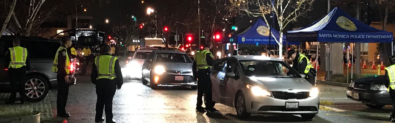
On July 10, 2026, the Santa Monica Police Department will conduct a driving under the influence (DUI) Checkpoint from 6 p.m. to 2 a.m. at an undisclosed location.

DUI checkpoint locations are determined based on data showing incidents of impaired driving-related crashes. The primary purpose of DUI checkpoints is to promote public safety by taking suspected impaired drivers off the road.

Impaired drivers put others on the road at significant risk. Any prevention measures that reduce the number of impaired drivers on our roads significantly improve traffic safety.

SMPD reminds the public that impaired driving is not just from alcohol. Some prescription medications and over-the-counter drugs may interfere with driving. While medicinal and recreational marijuana are legal, driving under the influence of marijuana is illegal.

Drivers charged with a first-time DUI face an average of $13,500 in fines and penalties, as well as a suspended license.

Funding for this program was provided by a grant from the California Office of Traffic Safety, through the National Highway Traffic Safety Administration.


On Sunday, a person drives his vehicle fown the pedestrain ramp on the Santa Monica Pier and gets trapped damaging his truck between the palm trees. Pier employees show up to help him navigate his way out before causing anymore damage to the trees.


Caltrans doing overnight paving work on Pacific Coast Highway in Malibu and reducing PCH to one lane in each direction on Monday 4/13 & Tuesday 4/14 from 8PM to 6AM


On January 23, 2026, about 8:30 a.m. pacific standard time, a 2024 Jaguar I-Pace sport utility vehicle, equipped with an automated driving system (ADS) and operated by Waymo LLC, struck a 9-year-old student pedestrian crossing midblock within a school zone in Santa Monica, Los Angeles County, California.

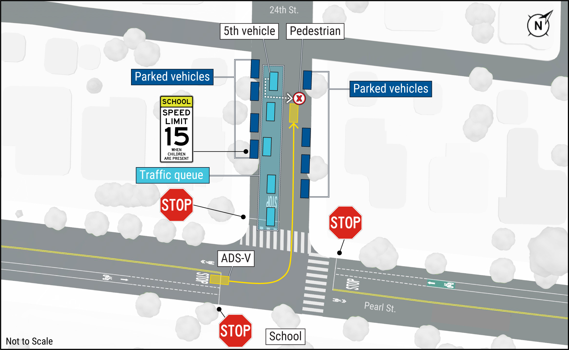
The unoccupied vehicle had completed a passenger drop-off on eastbound Pearl Street at the stop sign in front of an elementary school, turned left onto 24th Street, and proceeded north (see figure). The crash occurred in a 25-mph speed limit school zone, approximately 40 feet north of the end of the adjacent 15-mph speed limit school zone. The weather was clear, the roadway was dry, and daylight conditions were present.

According to video evidence from a school surveillance camera and from cameras on the ADS-equipped vehicle, a queue of five vehicles had formed in the southbound lane of 24th Street at the stop-controlled intersection with Pearl Street. The student pedestrian exited the right rear door of the fifth vehicle in the queue. The pedestrian then moved toward the front of her vehicle and entered the roadway, crossing at a rapid pace between her vehicle and a Chevrolet Suburban sport utility vehicle stopped in front of her vehicle.

The ADS-equipped vehicle was traveling north on 24th Street at 17 mph. According to video evidence, the vehicle braked and collided with the student pedestrian near its front-right headlight assembly. Post-impact, the pedestrian fell, then walked to the east curb of 24th Street. The vehicle continued braking and came to rest within the northbound travel lane almost immediately.

After the collision, a Waymo remote assistance agent in Novi, Michigan, contacted 911 and later provided the vehicle with directions to move to the curb on 24th Street north of the crash site.The vehicle remained at that location until the Santa Monica Police Department arrived. As a result of the collision, the student pedestrian reported minor injuries and did not require medical transport.

Parties to the National Transportation Safety Board (NTSB) investigation include:

Santa Monica Police Department

Waymo LLC All aspects of the crash remain under investigation while the NTSB determines the probable cause, with the intent of issuing safety recommendations to prevent similar crashes.


As part of the Pier Bridge Replacement Project, construction crews will temporarily close the Moomat Ahiko Way off-ramp from southbound Pacific Coast Highway from Feb. 9 through Feb. 27 to construct the foundation for a temporary pedestrian bridge ahead of the pier bridge reconstruction.

The pedestrian bridge will ensure continued access to the Santa Monica Pier throughout the project.

Motorists traveling to the area are advised to allow for extra travel time and use alternate routes during the two-week off-ramp closure period. A map of suggested detours is available here.

Pier restaurants, shops and entertainment, as well as parking and visitor access will remain open and accessible throughout the Pier Bridge Replacement construction period, ensuring residents and visitors can continue to enjoy the Pier with minimal disruption.


A Waymo vehicle struck a child on Friday, January 23. According to the NHTSA, the incident occurred within two blocks of a Santa Monica, CA elementary school during normal school drop off hours and that there were other children, a crossing guard, and several double-parked vehicles were in the vicinity. The child ran across the street from behind a double parked SUV towards the school and was struck by the Waymo AV. Waymo reported that the child sustained minor injuries.

At the time of the incident, the Waymo AV was operated by Waymo’s 5th Generation Automated Driving System (ADS). No safety operator was present in the vehicle.

Waymo released a statement:

"At Waymo, we are committed to improving road safety, both for our riders and all those with whom we share the road. Part of that commitment is being transparent when incidents occur, which is why we are sharing details regarding an event in Santa Monica, California, on Friday, January 23, where one of our vehicles made contact with a young pedestrian. Following the event, we voluntarily contacted the National Highway Traffic Safety Administration (NHTSA) that same day. NHTSA has indicated to us that they intend to open an investigation into this incident, and we will cooperate fully with them throughout the process.

The event occurred when the pedestrian suddenly entered the roadway from behind a tall SUV, moving directly into our vehicle's path. Our technology immediately detected the individual as soon as they began to emerge from behind the stopped vehicle. The Waymo Driver braked hard, reducing speed from approximately 17 mph to under 6 mph before contact was made.

To put this in perspective, our peer-reviewed model shows that a fully attentive human driver in this same situation would have made contact with the pedestrian at approximately 14 mph. This significant reduction in impact speed and severity is a demonstration of the material safety benefit of the Waymo Driver.

Following contact, the pedestrian stood up immediately, walked to the sidewalk, and we called 911. The vehicle remained stopped, moved to the side of the road, and stayed there until law enforcement cleared the vehicle to leave the scene.

This event demonstrates the critical value of our safety systems. We remain committed to improving road safety where we operate as we continue on our mission to be the world’s most trusted driver."

A parent posted this statement online:

"Happened in my kids school, grant elementary. From everything I heard, it’s the kids/parents fault for sure. They let the child out on the opposite side of the street ad the kids ran behind a car to cross the street. There is a crossings guard just next to him but they still ran. I hope they will charge the parents for negligence. I’m not here to protect a corporation but I believe that if it was a human driver the kid would had it worse."

Find out about more upcoming local events, Click Here for the Event Calendar.


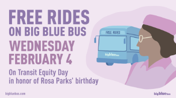
Big Blue Bus honors Rosa Parks’ birthday and Transit Equity Day, with FREE RIDES on Wednesday, February 4, 2026 To honor the legacy of Civil Rights Activist Rosa Parks, Transit Equity Day is celebrated nationwide as a day of action supporting equitable, affordable, accessible, reliable, and safe transit for all. This year’s theme, “Transit Moves Democracy”, highlights the work being done by community leaders, environmentalists, and social justice advocates fighting for equitable, accessible, and fully funded sustainable public transit systems in our communities. Find out about more upcoming local events, Click Here for the Event Calendar.


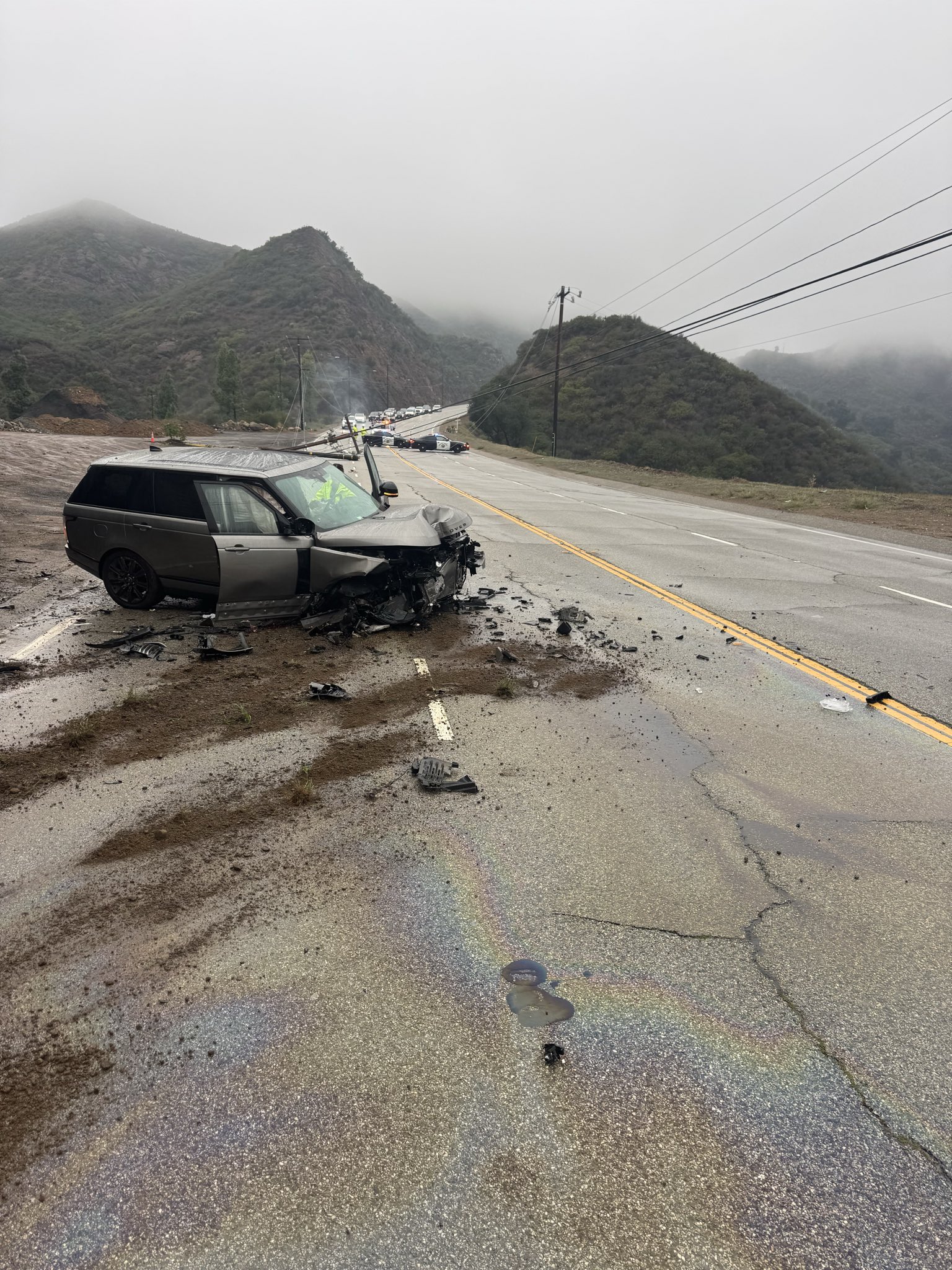
Due to a traffic crash and downed power lines, Kanan Dume Road was closed between Newton Canyon Road (just north of Tunnel 1) and Cavalleri Road on Friday.


For more news, updates and traffic conditions on PCH and other local beachside roads, Click Here.


Caltrans will close a 3.6-mile stretch of Topanga Canyon Blvd between PCH and Grand View Dr TODAY, Thursday, Nov. 13, 10 PM ahead of heavy rain expected overnight and through the weekend.

The closure will remain in place until conditions improve, likely through the Friday morning commute and possibly into the weekend. The National Weather Service forecasts 2–4 inches of rain, with peak rainfall rates up to 0.7 inches per hour, raising the risk of debris flow in burn scar areas.

Caltrans crews are securing the area with k-rail, sandbags, and stabilization work as part of ongoing Palisades Fire recovery efforts.

Drivers should use alternate routes, expect delays, and avoid travel during heavy rain, especially near burn areas. Motorists should keep headlights on, and watch for workers and work vehicles in the road. Never touch downed power lines - stay back, warn others, and call 911.

For more news, updates and traffic conditions on PCH and other local beachside roads, Click Here.


CALTRANS PLANS FOR LANE CLOSURES FOR WORK ON PACIFIC COAST HIGHWAY IN MALIBU, WEEK OF NOV. 3 - 9 CURRENT CONDITIONS / SPEED LIMITS • Temescal Canyon Rd – Sunset Blvd: 35 mph, cones and signage in place.
• Sunset Blvd – Carbon Beach Terrace: Active work zone, single-lane closures, 25 mph.
Crews may set up closures weekdays, 9 a.m.–3 p.m.

POTENTIAL LANE CLOSURES IN ACTIVE WORK ZONES • Ventura County Line – Carbon Beach Terrace: Work near Trancas Canyon Rd–Guernsey Ave and Corral Canyon Bridge; possible night closures.
• Kanan Dume Rd – Ramirez Canyon Rd: 7 a.m.–4 p.m. Nov. 6–7, one northbound lane closed.
• Latigo Canyon Rd – Puerco Canyon Rd: 7 a.m.–3 p.m. Wed–Fri, one northbound lane closed.
• Las Flores Canyon Rd – Sunset Blvd: Fire damage, slope, and drainage repairs; lane closures as needed, 9 p.m.–6 a.m.
• South of Big Rock Dr: Northbound reduced to one lane, 9 a.m.–3 p.m. weekdays.
• Las Flores Canyon – Topanga Canyon Blvd: SCE trenching; northbound lane/shoulder closures 4 a.m.–3 p.m. weekdays, 4 a.m.–4 p.m. weekends, 9 p.m.–6 a.m. daily. Southbound closures 9 a.m.–5 p.m. weekdays, 4 a.m.–4 p.m. weekends, 9 p.m.–6 a.m. daily.
• South of Topanga Canyon Blvd: Rock mitigation, 6 a.m.–3 p.m. weekdays, one northbound lane closed about half a mile south.
• Coastline Dr – Porto Marina Way: Retaining wall work near Getty Villa, 9 a.m.–3 p.m. weekdays, one northbound lane closed.

For more news, updates and traffic conditions on PCH and other local beachside roads, Click Here.


On Friday, October 24, 2025, at approximately 9:15 p.m., the Santa Monica Police Department responded to reports of a severe traffic collision involving a vehicle and multiple pedestrians in the 1300 block of Wilshire Boulevard.

Upon arrival, officers located four victims on the south sidewalk. The Santa Monica Fire Department responded and transported two individuals to a local hospital with injuries. They are expected to survive. Tragically, two victims were pronounced deceased at the scene.

Preliminary information indicates the involved vehicle was traveling westbound in the eastbound lanes of Wilshire Boulevard when it drove onto the sidewalk and struck the four pedestrians. The involved vehicle remained at the scene; however, the driver fled on foot prior to officers’ arrival and remains outstanding.

The suspect is described as a Black male, approximately 6 feet tall, last seen wearing a red hat, a black sweater, and black shoes.

The Santa Monica Police Department’s Major Accident Response Team (MART) is leading this criminal investigation. Wilshire Boulevard between 14th Street and Euclid Avenue was closed for several hours as investigators processed the scene.

“We recognize the gravity of this tragedy and the impact it has on our community,” said Interim Chief Darrick Jacob. “Our investigators are working tirelessly to identify and locate the suspect responsible, and our hearts are with the families of the victims who are experiencing unimaginable loss.”

For more news, updates and traffic conditions on PCH and other local beachside roads, Click Here.


The City of Malibu has proposed two quick-build roundabouts on PCH/State Route 1 (SR-1) in coordination with Caltrans. This pilot project will install temporary roundabouts at PCH intersections with Encinal Canyon Road and El Matador Beach Road. The project aims to calm traffic, improve pedestrian safety, and add dedicated bike lanes to help assess the feasibility of permanent roundabouts.

The City of Malibu, in coordination with Caltrans, is advancing a quick-build pilot project currently in the Project Initiation Document (PID) phase. The project proposes the temporary installation of roundabouts at two key intersections along PCH: Encinal Canyon Road and El Matador Beach Road. The intent is to improve safety by slowing vehicle speeds, enhancing pedestrian crossings and reducing crash severity.

The corridor will be reconfigured from a four-lane roadway to two single-lane roundabouts with dedicated bike lanes, pedestrian refuge areas and buffered parking. Community feedback gathered during the pilot will help determine the feasibility of permanent installations at these and other locations along the corridor.

The purpose of the project is to improve safety and efficiency for all users of PCH by placing the roundabouts at both intersections. This will reduce vehicle speeds, create safer conditions for pedestrian crossings and provide them safe refuge and improve visibility.

The existing conditions between Encinal Canyon Road and El Matador State Beach consist of four travel lanes (two in each direction) with a two-way left turn lane, and a 55 mph speed limit. It creates an unsafe condition for pedestrian activity and vehicular turning movements at the two locations. The roundabouts are intended to improve safety for people walking, biking and driving. This will be achieved by redesigning PCH at these intersections to reduce vehicle lanes from two to one, which decreases crossing distance and overall speed of vehicles in the area. Construction is expected to begin in early 2026.

For more news, updates and traffic conditions on PCH and other local beachside roads, Click Here.


Due to the anticipated storm, Caltrans will close Topanga Canyon Boulevard between Pacific Coast Highway and Grand View Drive today, October 13 at 10:00 PM until Tuesday, October 15 at 5:00 AM.

Caltrans will monitor the situation and evaluate reopening in the morning, depending on the amount of rainfall.

⚠️ Los Angeles County Public Works has issued a PHASE 2 mudflow forecast for the Franklin Fire and Palisades Fire burn areas in Malibu. Some streets may become completely blocked by debris. The Evacuation Warning remains in effect.

The City will continue monitoring the situation and is ready to activate the Emergency Operations Center if necessary.


For more news, updates and traffic conditions on PCH and other local beachside roads, Click Here.


A 16-inch water main broke at 2:30 AM on Tuesday causing a huge sinkhole on Venice between Alberta Avenue and Canal Street.

The water main break resulted in more than 30 homes losing water service and caused significant damage to North Venice Boulevard.

Roads are closed as crewswork into the night.


For more news, updates and traffic conditions on PCH and other local beachside roads, Click Here.


CURRENT PALISADES FIRE AND EMERGENCY WORK LANE CLOSURES Week of October 6 - 12


Please note that crews on PCH may set up single-lane closures anytime within the 9 a.m. to 3 p.m. weekday working hours. Those below are currently planned, but there may be others. Closures are weather-permitting and subject to change. Motorists should expect delays and are advised to use alternate routes during construction hours. View current traffic conditions by visiting the Caltrans Quickmap.

Pacific Coast Highway (PCH/State Route 1) from Sunset Boulevard in Pacific Palisades to Carbon Beach Terrace in Malibu

Current road conditions/speed limits

McClure Tunnel to Temescal Canyon Road: No restrictions; returned to 45 mph speed limit

Temescal Canyon Road to Sunset Boulevard: Reduced speed limit with cones and signage, 35 mph

Sunset Boulevard to Carbon Beach Terrace: Remains an active work zone, subject to single-lane closures and 25 mph speed limits

Potential lane closures in active work zones

· Ventura County Line to Carbon Beach Terrace

o From Trancas Canyon Road to Guernsey Avenue: Designated work zones, possible nighttime closures

o Corral Canyon Road Bridge repairs: Designated work zones, possible nighttime closures

· South of Las Flores Canyon Road to Sunset Boulevard

o Repair fire-damaged roadway, drainage and electrical systems, and slope repairs

o Lane closures only as needed, 9 p.m. to 6 a.m. daily

· Just south of Big Rock Drive (closure extends less than half a mile)

o Northbound reduced to one lane 9 a.m. to 3 p.m. Monday to Friday

o 8 p.m. Monday, Sept. 29 to 6 a.m. Tuesday, Sept. 30 and 8 p.m. Wednesday, Oct. 1 to 6 a.m. Thursday, Oct. 2: PCH reduced to one lane in each direction

· Big Rock Drive to Topanga Canyon Boulevard (SR-27)

o Southern California Edison trenching operation

o Northbound outermost lane and shoulder closures

• 4 a.m. to 3 p.m. weekdays

o Southbound outermost lane and shoulder closures

• 9 a.m. to 5 p.m. weekdays

• 4 a.m. to 4 p.m. weekdays

· Just south of Topanga Canyon Boulevard (SR-27)

o Rock mitigation repairs

o One lane of northbound PCH closed from Topanga Canyon Boulevard intersection to about a half-mile south

• 6 a.m. to 3 p.m. weekdays

Topanga Canyon Boulevard (SR-27) from Pacific Coast Highway to Grand View Drive

Current road conditions and closures

· This stretch of SR-27 remains closed to motoring public from midnight to 5 a.m. daily

· One-way traffic control with a pilot car, postmile 2.5 to 2.8 for Caltrans emergency project work, 5 a.m. to midnight daily

· One-way traffic control for SCE trenching operation, postmile 4.3 to 6.7, 8:30 a.m. to 5:30 p.m. daily

· One-way traffic control for SCE overnight work, between Grand View Drive to south of Topanga town center: 10 p.m. to 6 a.m. weekdays

For more news, updates and traffic conditions on PCH and other local beachside roads, Click Here.


Los Angeles - Caltrans announces extended weekend lane reductions along Interstate 405 (I-405) through the Sepulveda Pass. The freeway will be reduced to three lanes in each direction and motorists are strongly encouraged to seek alternate routes and explore public transportation options to reach their destinations.

The work will start at 10 p.m. Friday, Sept.19 through 5 a.m. Monday, Sept. 22. Motorists traveling along I-405 will experience the following lane reductions and closures:

Northbound Interstate 405

Northbound I-405 will be reduced to three lanes between Santa Monica Boulevard to just north of Sunset Boulevard

Santa Monica Boulevard on-ramp closed

Sunset Boulevard on-ramp will be open

Southbound Interstate 405

Southbound I-405 will be reduced to three lanes just north of Sunset Boulevard to Wilshire Boulevard

Sunset Boulevard/Church Lane on/off-ramp closed

Southbound I-405 off-ramp to Eastbound and Westbound Wilshire Boulevard closed

For more news, updates and traffic conditions on PCH and other local beachside roads, Click Here.


Topanga Canyon Boulevard (SR-27) will be restricted to one-lane traffic from 10 p.m. Friday to 8 a.m. Saturday between Mulholland Drive to Happy Trail for striping.

The areas of one-way traffic may adjust. Crews will post signage ahead of closures.

For more news, updates and traffic conditions on PCH and other local beachside roads, Click Here.


Pacific Coast Highway will be reduced to one lane in each direction south of Big Rock Drive in Malibu from 7PM to 5AM the night of Friday 9/5 to shift lanes, stripe & place k-rail for a retaining wall project.

For more news, updates and traffic conditions on PCH and other local beachside roads, Click Here.


The Santa Monica Police Department (SMPD) will conduct a traffic safety operation on Friday, August 29, 2025 from 8 a.m. to 6 p.m. focused on the most dangerous driver behaviors that put the safety of people biking or walking at risk.

These violations include speeding, making illegal turns, failing to yield or provide right of way to bicyclists or pedestrians, or failing to stop for signs and signals.

We all have places to be and not everyone gets there by car. Bicyclists and pedestrians have the same rights to the road but face even more risk without the protections vehicles have. We should all be looking out for one another.

SMPD offers steps drivers and pedestrians can take to greatly reduce the risk of getting injured or in a crash:

Pedestrians

Be predictable. Use crosswalks, when available.
Take notice of approaching vehicles and practice due care.
Do not walk or run into the path of a vehicle. At 30 mph, a driver needs at least 90 feet to stop.
Be visible. Make it easy for drivers to see you – wear light colors, reflective material and carry a flashlight, particularly at dawn, dusk or at night.
Be extra careful crossing streets or entering crosswalks at night when it is harder to see, or when crossing busier streets with more lanes and higher speed limits.

Drivers

Do not speed, and slow down at intersections. Be prepared to stop for pedestrians at marked and unmarked crosswalks, and between intersections where pedestrians may cross.
Avoid blocking crosswalks while waiting to make a right-hand turn.
Never drive impaired.

Bicyclists

Obey traffic laws, use hand signals, use lights at night (front white light and rear red reflector), and wear a helmet.
Bicyclists must travel in the same direction of traffic and have the same requirements as any slow-moving vehicle.
Avoid the door zone: do not ride too closely to parked cars.
If there’s a bike lane, use it, unless making a left turn, passing, or approaching a place where a right turn is allowed.
Yield to pedestrians. Bicyclists must yield the right-of-way to pedestrians within marked crosswalks or within unmarked crosswalks at intersections, and between intersections where pedestrians may cross.